Orbiting 6 PNW Volcanoes
This isn't a "thing" like the Bulger list. Unless you want it to be. In total these orbits work to be 403 miles with 82,500 feet of elevation, give or take. Although each of these 6 volcano orbits are posted on this blog, I'll synopsize each one and provide a link for those interested in the details. I will list them in order of difficulty, at least in my humble opinion. Orbiting the 6 major PNW volcanoes samples some of the best the Cascade Range has to offer. Loops in general are desirable, not having to repeat sections like out and backs. The eyes take in ever changing terrain as one orbits the central mass, each mountain presenting a new face from different angles and elevations and the trails taking the hiker through different ecological zones. In short, these are just very cool trips.
#1 MT. HOOD TIMBERLINE TRAIL (40 miles/8,000')
The Timberline is longer than St. Helens (Loowit) and Mt. Adams, but my daughter and I found this trail delightful in all aspects and fairly straightforward. Moderate elevation gains on forgiving trail and terrain, rife with crystalline water sources. When we did this trail it was still officially closed because of the eradicated section across Eliot Creek. It was still doable of course, one simply had to scurry on unofficial trail into the gorge. There were even fixed ropes on either side for assistance. Suitable fords could be found with minimal scanning of the roiling water. Now the trail is officially reopened with a rerouted section lower down with a bridge, eliminating the only real difficulty on the orbit. Aside from a number of feet wet crossings, the Timberline provided scenic nonstrenuous travel through various zones. Although we took 3 days for this trail, most of the first day was involved with travel and we finished early on the 3rd day.

The Timberline offers a wide variety of views

Fording Eliot Creek; no longer required with the recent reroute
#2 MT. ST HELENS LOOWIT TRAIL (30 miles/7,000')
Although shorter with less elevation gain than the Timberline, I would have to put the Loowit as slightly more difficult simply because of the boulder fields, exposed areas that offer little respite from the baking sun reflecting off the northern lava fields, fewer water sources and some scrambly ravine crossings (one with ropes). It's one of a kind though, in that the 1980 eruption evidence is still visible and ever changing. Ghostly trees are laid out in one direction, sometimes amidst grasses, flowers and new growth. Transiting the blast zone is surreal, especially as one enters or exits the two borders on the east and west sides. Go from moonscape to old growth in the same day. This trail should be on everyone's list.
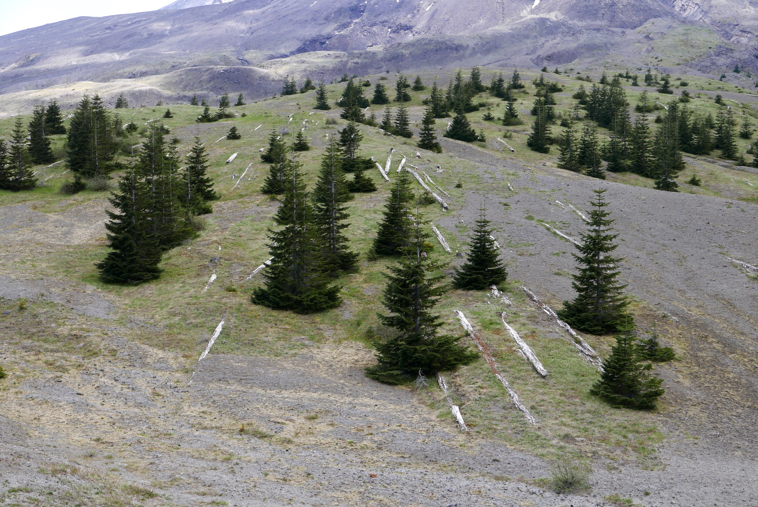
New growth amidst the fallen on Mt. St. Helens' Loowit Trail

Looking back on Pumice Plain, Mt. St. Helens north side blast zone
#3 MT BAKER (95 miles/10,500')
Baker is an odd one for sure, as there is no trail that encircles the mountain. There have been ski circumnavigations and even a party of two that battled incessant devil's club in an off trail journey more than a decade ago. Emulating that trip would elevate this orbit to the most difficult spot, but if one thinks out of the box there is an easier way around. I completed this orbit in 2 days by transiting the west side via bike, eventually forging back closer to the mountain on FS Road 38, where I stashed the wheels (after 58 miles) and took to ambulation. By connecting various trails and roads (starting with Ridley Creek), I was able to regain my vehicle at the Lake Ann trail head after 37 miles of walking/trotting. I pushed hard on the first day, completing 22 miles of hiking after the bike portion, stopping around midnight for some rest. This allowed me to finish early enough on day 2 to drive around and retrieve my bike, which took almost 2 hours just for FS 38 (13 miles one way and rough) and be home that night. Plan accordingly if contemplating this orbit, not just for the logistics of involving a bike drop off and pickup, but for packing requirements for these two disciplines. In the grand scheme of things none of this was particularly difficult, just a bit odd. But the Mt. Baker Wilderness is a jewel and I found that riding Highway 542 and the other connecting roads around was extremely pleasant in its own right, something to be enjoyed and not endured.

Delights along the road during the 58 mile bike section, Mt. Baker orbit

Mt. Baker in view on the Park Butte trail, part of the orbit
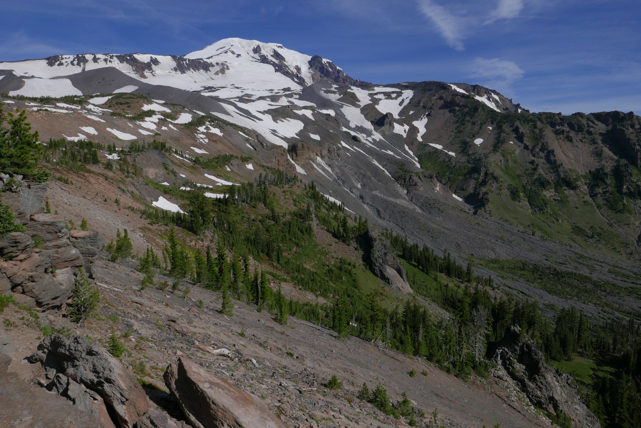
#4 MT. RAINIER'S WONDERLAND TRAIL (93 miles/22,000')
The distance and elevation are not easy by any means, and the time commitment for some parties might make logistics a concern. The Wonderland also requires permits, adding to the logistics mix. However, this whole trail is well maintained and every backcountry camp has a loo and bear poles. One can also resupply from caches stowed beforehand, and there are multiple places for possible meetup with support (Longmire, Sunrise, White River, Box Canyon, Reflection Lakes, Mowich Lake and even Carbon River if you want to walk the 5 miles to the entrance). Mt. Rainier has been my stomping ground since the early 80's; I have done the Wonderland about 30 times, taking from 36 hours to 6 days. Obviously something keeps me coming back, so this destination hike is well worth the visit.

St. Andrews Lake on the Wonderland, Sep 2015

A snow free Panhandle Gap (6800'), highest point on the Wonderland Trail
#5 MT. ADAMS (35 miles/8,000')
With stats akin to Hood and St. Helens, at first glance one might wonder why I rank this orbit harder than the Wonderland. A quick study of the map and the answer becomes evident....there is no trail on the rugged east side (on Yakama land). The "Round-The-Mountain" trail doesn't go 'round the mountain. In orbiting (lower than the Green Trail Map) one must contend with the 5 mile off trail section with a skill set that goes beyond basic backpacking. Map reading, route finding, river fording and confidence are a must. However, technically nothing more than mild scrambling is required. I transited the Yakama section in one day so permits were not an issue, and once back on trail the going is easy, scenic and delightful. This orbit is not often done, so this adds to one's sense of accomplishment. This was a two day trip for me.

Mt. Adams from Devils Garden
Start of the off trail portion on Mt. Adams east side
#6 GLACIER PEAK CIRCUMNAVIGATION (110 miles/27,000')
Glacier Peak presents some difficulties above the others. There are various ways to orbit the mountain, the shortest using High Pass to the Napeequa on the east side. This requires off trail (although there is an evident path) travel, however. Going further east lengthens the trip to over 100 miles (110 for my iteration), with elevation gains upwards of 27,000'. Another tick of difficulty is negotiating the south side trails; White River is reportedly a nightmare of blowdown, washouts, brush and scant trail that hasn't seen maintenance in over 10 years. Indian River is better, but also unmaintained. It's hot, buggy with overgrown brush (frequently head high), rife with blowdown and washed out areas. 11 miles of pure delight. Bailout options are few and difficult, and resupply would also present challenges. Many parties take more than a week for this trip, carrying 7 to 12 days of food. But I'm just listing some difficulties here, the rewards are immense. Some consider this orbit, and the Glacier Peak Wilderness area in general, to be some of the best in the Cascades. I tend to agree.

The verdant Napeequa Valley on the climb to Little Giant Pass, Glacier Peak

Glacier Peak from the west side on the PCT
SUMMARY
My trips involved 17 days total, with 3 of these orbits taking 2 days (Loowit, Adams, Baker) and the Timberline certainly doable in 2. I fastpacked the Wonderland in 2015 in 3 days, and my recent and last Glacier Peak orbit was over 5 days. If the reader uses this info as a guide, consider that some of my days were quite long, i.e. a 35 mile day on the Wonderland, an 80 mile day on Baker (incl. biking), and a few longer days around Glacier Peak to average 22 miles per day (stopped at midnight on day 4). For max enjoyment and less punishment, I might suggest 2 for Loowit, 3 for Hood, 3 for Adams, 3 or 4 for Baker, at least 7 for Rainier's Wonderland and 9 for Glacier Peak, for a total of about 28 days. Glacier Peak offers the most variety for putting a trip together, limited only by your imagination. I got to enjoy half of these trips (Loowit, Timberline, Wonderland) with my daughter, adding to each unique sojourn. If anything, completing these orbits introduced me to fantastic areas outside my usual stomping ground; indeed, they kindled a desire to explore more of the North Cascades and helped open my eyes to the vast outdoor playground here in the Pacific Northwest.

Willis Wall on the Indian River trail, 2016