Mt. Hood Timberline Trail (RTM)
 Warning on the Cloud Cap sideFirst it should be noted that the Timberline Trail is officially closed over Eliot Creek ever since a washout occurred in 2006, eradicating that portion of the trail. However, one can still negotiate the entire circuit by crossing the Eliot area at your own risk. Do a quick search and lots of info will pop up from Oregon Hikers and other sources. See below for more information on this crossing. Otherwise we found the Timberline trail to be quite delightful and easily doable in two days, although in our case with the drive we didn't start the hike CW from Timberline lodge until noon on day 1. Various sources say the Timberline is 40 miles with 8,000 feet of climb. We started our hike on August 17. Timberline Trail photo set here.
Because of the 4 hour drive, with stops for food and lunch at the parking lot, we didn't actually start hiking until noon on Monday. The Warm Springs fire in Oregon made for hazy skies and washed out horizons, a typical scene in the Northwest recently for sure. The trail starts out sharing the PCT, where we crossed a creek on the only bridge we would see for the rest of the hike. There are a few things that make the Timberline "delightful", one being the abundant fresh water sources found all around the trail (no need to tanker), the other being the excellent tread and mild inclines....ultra runners must love this area, as one can stride steadily with little interruption both uphill and downhill. However, interruptions there are, and these come in the form of glacial torrents which must be negotiated on one's own, don't expect any blow downs to assist. Each crossing requires study for the best passage, and we found that 5 times we had to go feet wet. In any event, our first day was just trying to forge at least 15 miles up the trail to get established so our second day wouldn't be too extreme. Luckily, right at 7 PM and 15 miles in we found an excellent bivy spot in the woods and settled down for some good sleep in anticipation of the next day.
Day 2 had us wondering when the great trail would peter out, but it never did. We did a crossing or four and strode with the heat in mind until we finally came to the infamous Eliot Creek crossing, where an ominous sign just begged for us to peek over the edge. What we saw was a little daunting, but the unofficial trail kept going up and we followed this to an obvious point where we could descend, very hard to miss. This trail brought us to the western rope, which was supposed to be the steepest, but in truth the slope looked very doable without assistance. However, we utilized the rope anyway and eventually made our way to the creek proper. In my impatience I just forged across right across from the opposite trail but I would highly recommend that one avoid this, as the rushing water was boiling up to my waist. There are some big rocks that can be lept for those going light and agile enough but we opted out. Even before I was across Cassie was thinking "no way am I crossing there", and I was thinking "no way is she crossing here." She made her way upstream with me paralleling her course on the other side until a much milder shin deep ford was possible, and I was thinking "I shoulda gone there." We made our way down stream to pick up the even milder trail and rope assist that took us back to the top of the moraine and down a short section of unofficial trail to reintercept the "real" Timberline.
 setting sun on Mt. Hood's Yokum Ridge
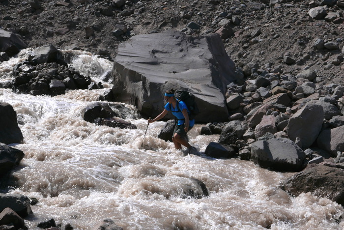 crossing the freezing and raging Eliot CreekFrom there we began a gradual climb up to the highest point on the trail (7300') past the Cooper Spur trail with wide open views of the mountain and the hazy horizon. After a long chat with a couple camped at the high point, we started a nice trot on excellent trail that took us into nightfall, where we negotiated two more river crossings in the dark. However, the final crossing at the White River before finishing up was described as "most difficult" and we decided that we would get within 5 miles of the destination and find a place to bivy, allowing us a full night's sleep, an easier drive and a daylight crossing of the "most difficult" river, which turned out to be a relative piece of cake. However, the wide flood plain in fact would have proved difficult for night navigation so we were glad we waited. We arrived back at our vehicle well before 10 AM so enjoyed the rare experience of cleaning up, eating lunch and driving IN DAYLIGHT back home....wow. To sum, we enjoyed this trail so much we both agreed that a future repeat visit was not out of the question.
  sunset on the Cooper Spur